 |
|
|
Volume XV |
June 2010 |
Number VI |
|
Listen to Cultural Energy Radio Online |
Celebrando Las Acequias: Past, Present, and Future Cañada de Cochiti: The Chicanery of Reducing a Legitimate Land Grant By Mark Schiller |
Action AlertUpdate on the Lower Rio Grande Adjudication By Kay Matthews Rio Arriba County Institutes Moratorium on Development of Agricultural Lands By Kay Matthews |
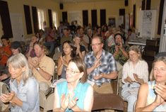
Celebrando Las Acequias: Past, Present, and FutureAt the June Celebrando Las Acequias: Past, Present, and Future, held at the Embudo Mission building in Dixon, two mayordomos of the year were honored: Gene Martinez, posthumously, and Dan Lovato from the El Bosque Acequia. Two farmers of the year were also honored: Jasper Tucker from Rio Embudo Vines, and Matt Romero of Romero Farm. The event, which has been held for several years now, recognizes the role the acequias play in the growing of food in the community and honors those who take care of the water &endash; the mayordomos &endash; and those who grow the food &endash; the farmers. This year the event was held in conjunction with the Arid Lands Institute at Woodbury University in Burbank, California, whose mission "is to train designers and citizens to be resourceful and inventive in the face of water scarcity and hydrologic variability brought on by climate change." Photos by Seth Roffman
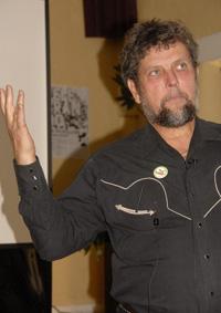
Dr. Gary Nabhan, who spoke about native foods Cañada de Cochiti: The Chicanery of Reducing a Legitimate Land GrantBy Mark SchillerEditor's Note: This is the third in a series of articles evaluating the effect George W. Julian's tenure as Surveyor General of the New Mexico territory (1885-1889) had on the process of adjudicating Spanish and Mexican land grants. Mark Schiller's work is the result of a grant La Jicarita News received from the New Mexico Historical Records Advisory Board. Next month we will run the conclusion of the series.
Another precedent setting claim Julian singled out to discredit in his "Land Stealing in New Mexico" article was the Cañada de Cochiti. Of this claim Julian wrote: "The Cañada de Cochiti grant is dated August 2d, 1728. The grantee petitioned for a 'piece of land to plant thereon, and on said piece of land to cultivate ten fanegas of wheat and two of corn,' being about 32 acres, and to pasture his 'small stock and horse herd.' The validity of the grant is not shown, nor is there an equitable claim; but it was approved by the Surveyor-General, and the survey covers a strip of land averaging from five to six miles in width, and from twenty-five to thirty in length, aggregating an area of 104,554 acres, or a little more than 163 square miles. The whole of this tract is reserved from settlement in behalf of the monopolists who claim it without right." Julian's judgment of this claim was, by and large, misleading or false. The facts of the claim are as follows. The grant was requested by a landless Albuquerque resident Antonio Lucero, who as Julian noted, requested it for planting wheat and corn and the pasturage of his herds of small stock (presumably sheep and goats) and horses. In his petition Lucero outlined the boundaries of the tract: "On the north, by the old Pueblo of Cochiti; on the east, by the Del Norte River [Rio Grande]; on the south, by the lands of the Indians of Cochiti; and on the west, by the Jemez Mountains." (The interpretation of these boundary calls would later prove decisive and set a precedent regarding on whom the burden of proof fell in determining the location of a disputed boundary.) The Governor, Juan Domingo de Bustamante, granted Lucero's request on 2 August, 1728 and directed the Alcalde of San Felipe, Santo Domingo, and Cochiti, Andres Montoya, to place him in possession of the tract after consulting members of the adjoining Pueblos and determining that these boundaries did not conflict with their grants. On 6 August Montoya, after determining that "no person whatever who, under a better right, might claim the same," delivered possession of the grant [as outlined in Lucero's petition] to Lucero." Lucero and his heirs resided on and remained in continuous possession of the grant. On April 1, 1867 Felipe Sandoval, husband of one of Antonio Lucero's great-great-granddaughters, filed the original petition and concession of the grant, which by this time had considerably deteriorated, with the Office of the Surveyor General. Along with these documents, Sandoval presented an 1817 copy of the petition, concession, and act of possession, certified by the Alcalde of Cochiti, Juan Antonio Cabeza de Baca. Sandoval, however, failed to petition the Surveyor General to investigate the claim, probably because he could not afford to hire an attorney to draft one. Having occupied the grant for at least five generations, this clearly was a case of the legitimate Mexican owners being forced to sell to a land speculator because they could not afford to pursue their claim. So it was not until 1882, after Joel Parker Whitney, a wealthy California rancher and western lands speculator had purchased the interest of the majority of Lucero's descendants, that the claim was investigated by Surveyor General Henry M. Atkinson, probably the most corrupt of all New Mexico's Surveyors General. It is unclear whether Sandoval or Whitney submitted a third set of documents showing that in 1785 Cayetano Montaño and eleven other "actual residents and heirs" of the grant protested the appropriation of portions of the grant by the lieutenant of the garrison at Cochiti Pueblo for grazing the soldiers' horses. The documents included the response of the local Alcalde, Antonio de Armenta, who noted the legitimacy of the grant and upheld the protest. Additionally, Atkinson took extensive testimony from four Hispano witnesses associated with the grant, only one of whom had an actual interest in it. The testimony, which included that of the son of the alcalde who made the certified copy of the grant papers, underwrote the legitimacy of the certified copy, established that there was a town on the grant that predated the Territory's acquisition by the United States, and corroborated the boundaries as outlined in the grantee's petition. Atkinson, however, resorting to absurd legal technicalities and racism, systematically dismissed most of the claimants' evidence and testimony. Because Julian's dismissal of the claim is largely based on Atkinson's opinion, I will examine it in some detail. From the outset Atkinson conceded, "It is a matter of history that the old Spanish and Mexican archive of this territory were loosely kept after the American occupation of the country and many valuable documents and record books of these [land grant] titles were lost, destroyed, and sold as waste paper under the eyes of a Government official, whose sacred duty it was to preserve and protect them. The fact that these records were so destroyed has opened the door to fraud and invited imposition upon the Government through the means of fraudulent title papers, and necessitating the adoption of some rule as to the evidence of title required that may act harshly, and at times unjustly, towards honest claimants." In other words, instead of construing the government's negligence against itself and despite the certified copy of the grant and abundance of oral testimony that supported the legitimacy of the claim, Atkinson raised the specter of fraudulence because there was no record of the grant in the archive the United States inherited from Mexico. Moreover, he made the overtly racist assertion that "in view of the facilities that claimants possess of producing parol [oral] testimony of almost any character if so disposed, and which in many instances is known to be utterly unreliable, as shown by experience in the adjudication of this class of claims, it is under the circumstances an imperative duty to require the clearest and most satisfactory proofs of the validity of a title or claim presented in this form." Atkinson also summarily dismissed the 1785 documents concerning the protest of the grant residents against the garrison as "unauthenticated" and therefore inadmissible, although he admitted that if it were genuine it would "show the occupation and possession of the tract by the descendants of the grantee . . . at a period long anterior to that which it would be possible to show by oral evidence . . . ." He then took up the issue of whether the certified copy of the grant provided admissible evidence of the grant and concluded the copy would be material if "authenticated by an officer authorized to make the same." He went on to state, however, "I am unable to find where an alcalde was empowered to authenticate any document for the purposes of perpetuating the same." His reading of this issue, like Julian's, was clearly based on an Anglo-American interpretation of Spanish and Mexican law rather than an examination of the large body of Spanish and Mexican customary law and usage, which contained numerous instances of alcaldes making certified copies of official documents that had deteriorated. Having thus dismissed most of the claimants' evidence, he finally admitted on the fifth page of his opinion that "the parol proofs of long possession are strong" and "show a clear equity or claim which the Governments of Spain and Mexico would undoubtedly have recognized." Having made this concession, he then took up the issue of the extent of the grant. Atkinson made two arguments to limit the claim "for so much ranch land as was actually and bona fide used, occupied and held in peaceable, uninterrupted possession under claim of title, by Antonio Lucero, his heirs and assigns, under and by virtue of the presumed concession . . . . The extent of the tract so occupied, held and used to be clearly shown and established to be submitted prior to an official survey thereof . . . ." The first argument was that in making a grant "It was a custom . . . to give the applicant a usufruct of considerable tracts out of the royal domain for pastoral purposes and small tracts for cultivation and pasture of small herds were granted in fee . . . ." While there were examples of pastureland being available to all herdsmen in the vicinity of a large township (most of which was fully appropriated by the mid eighteenth century), this grant's boundaries were clearly defined and the land within those boundaries, as with the previously cited Cañon de Chama grant, was intended for the exclusive use of the grantees. The second argument Atkinson made was that the boundaries of the grant as outlined in the petition overlapped four other grants made subsequent to the Cañada de Cochiti and therefore evidenced the fact that these areas were only granted in usufruct and the government "did not recognize the existence of grant in fee, covering the extensive territory." Two of the four grants Atkinson lists had already been adjudicated and confirmed and therefore the land included within their surveys could not under federal law be contested even though there may have been significant grounds for doing so. The other two grants, adjudicated subsequent to Atkinson's opinion, were both rejected and therefore evidenced the opposite of what Atkinson argued. In any event, there were many instances of land grants that overlapped (further evidence of the difference between the Spanish and Mexican land tenure system that intended the land for use and the Anglo-American system that commodified the land for capitalist transaction) in which the government did not presume that the conflict implied that the older grant was limited by the boundaries of the more recent grant. In fact it often presumed the opposite. Consider, for example, the extraordinary case of the disputed overlap between the Town of Anton Chico and Preston Beck grants. Congress confirmed both grants for their full acreage despite the fact that the Surveyor General conceded that they overlapped by some 120,000 acres. Later, when the owners of the Preston Beck grant initiated a suite to partition the grant, the Board of Trustees of the Town of Anton Chico intervened claiming title to the disputed areas. Based on a previous Supreme Court decision, Jones v. St. Louis Land and Cattle Company, 232 U.S. 355 1914, also involving the Preston Beck grant, the trial court held that the Anton Chico grant preceded the Preston Beck grant and therefore took precedence with regard to the overlap. The owners of the Preston Beck grant, however, appealed the ruling to the New Mexico Supreme Court. That Court, in what amounted to a ridiculously convoluted and, I believe, unsubstantiated line of reasoning predicated on the Sandoval decision, held that because the Anton Chico was a community grant the unallocated, non agricultural lands (which included the overlap) within the grant's exterior boundaries remained the property of the Mexican Government and title to them passed to the United States Government upon the change of sovereignty. The 1860 Act of Congress, which confirmed the entire grant to the community, including the disputed overlap, therefore was a grant de novo by the United States government for which "the doctrine of senior or junior equities and of relation back has no application in the jurisprudence of such cases." Thus, because both grants were confirmed by the same Act of Congress, the date of application for confirmation became the deciding factor in determining which grant held superior claim to the overlap. The Preston Beck claimants prevailed because they submitted their petition for confirmation in 1855, while the Anton Chico claimants submitted theirs in 1859. This is another trenchant example of the absurd way the American system of jurisprudence dealt with claimants who were only seeking confirmation of what was legitimately theirs. Following Atkinson's recommendation that the claim be confirmed only for the land actually occupied by Lucero and his heirs and assigns, L. Harrison, Assistant Commissioner of the General Land Office, reviewed Atkinson's entire opinion and directed Atkinson's successor, Clarence Pullen, to survey the claim "according to the boundary calls in the grant, leaving final disposal of title to Congress." Pullen, having taken the depositions of three Cochiti Pueblo Indians regarding the location of the boundaries outlined in the grant, had the grant surveyed shortly before Julian took office in 1885 and determined the tract included 104,554.25 acres. At the end of February 1886 Julian reviewed the claim. He fully agreed with Atkinson, but was even more picayune in his assessment of the evidence. He asserted, for instance, "The Alcalde's report does not show that he notified the Indians or anyone else of the decree of the Governor, nor are the lands described, but only referred to as 'the lands expressed and mentioned in this grant.'" It was clearly stated in the alcalde's report that he had determined that no one else had a claim on the land in question and that he had adhered to the boundaries outlined in the petition. With regard to the extent of the claim Julian stated, "The area of the land thus prayed for [in Lucero's petition], according to a careful calculation I have caused to be made, would only be about thirty-two acres of tillable land, and pasture enough for the 'small stock and horse herd,' of the grantee, but it is now claimed that the Governor of New Mexico answered his petition by granting 104,554 acres; or a little more than 163 square miles. This is what the present claimants ask me to believe, and it is simply preposterous. It sets common sense completely at defiance. It is as improbable that a nation would thus throw away its public domain as that an individual would recklessly give away his private fortune." Julian then goes on to suggest, "But it is insisted that the boundaries of the grant cover this large area and that they are to govern. To this I reply, that if it were true that the alleged boundaries clearly and unequivocally cover so large an area it would powerfully strengthen the suspicion of the forgery of the papers relied on as evidence of title, because the petition and grant must be judged together, and it is not fair to assume that the Governor of this Province was ignorant of his duties or reckless of his obligations." So Julian, as I noted in the introductory article to this series, having conceded in his "Land Stealing" article that "At the date of these old grants, the Spanish and Mexican governments attached little value to their lands. They were abundant and cheap, and granted in the most lavish and extravagant quantities. Leagues, not acres, were the units of measurement . . . .", now construed the "lavishness" of the grant as proof of its fraudulence. Moreover, he once again ignored the realities of subsistence ranching in the arid southwest, requiring large areas of pasturage, and that Lucero's petition included the needs of his large and continually expanding family. Julian then went on to deny that even an equitable claim, based upon uninterrupted possession of the tract, was legitimate: "The long possession of the heirs of Lucero of portions of the land is not denied, but the character of the witnesses is not entirely beyond suspicion . . . . The possession of portions of the land may have been uninterrupted, but it can scarcely be said to have been sanctioned by the Spanish Government . . . . Mere possession without color of title confers no right by pre- scription against the Spanish Crown." Julian not only ignored the fact that continuous settlement or use of a grant was the most important criteria for validity under both Spanish and Mexican governance and the archival documents underwriting the legitimacy of the grant, but made the racist assertion that "the character of the witnesses is not entirely beyond suspicion" because there was slight variance in the witnesses' descriptions of the boundaries. Thus Julian's opinion, while basically agreeing with Atkinson's in principle, went beyond it in recommending "the whole of the tract claimed should be restored to the public domain, and I therefore recommend the rejection of this claim by Congress." Both Julian's and Atkinson's opinions would eventually be repudiated by the Court of Private Land Claim's decision in the case, although that decision would itself set a precedent that would negatively affect subsequent adjudications. While there was much testimony and dispute over the location of the western and northern boundaries of the grant, the Court of Private Land Claims held that the grant was valid within the north, south and east boundaries outlined in the original grantee's petition but fixed the western limit as the same as the northern boundary, "the old pueblo of Cochiti." This decision limited the claim to approximately 5,000 acres and was appealed to the Supreme Court, the crucial issues being the location of "the old pueblo of Cochiti" and the limit of the western boundary. The Supreme Court determined that the western boundary, indicated in the petition as the Jemez Mountains, could not be the same as the northern boundary, but fixed it at "the nearest sierra or other natural object that bears the name Jemez" rather than the summit of the highest peak in the Jemez mountains as the claimants contended. (In a 1998 ruling regarding a similar boundary call in the claim of the Sandia Pueblo grant, a federal court ruled that the grant extended to the highest crest of the Sandia Mountains rather than the first foothills of the Sandias.) Similarly, the Court ruled that despite there being two potential "old pueblo of Cochiti" sites, one of which lay seven miles to the northeast of the other, "The burden of proving the larger grant is upon the claimants. So long as the description is reconcilable with the smaller grant . . . the Government is entitled to the benefit of that construction." This legal precedent repudiated the Percheman decision that said, "[T]he [land] grants shall remain ratified and confirmed to the persons in possession of them, to the same extent, thus conforming exactly to the universally received law of nations, United States v. Percheman, 32 U.S. 51." This was a decision that Julian's article fully supported. He had written in the "Land Stealing" article regarding the surveyors contracted by Office of the Surveyor General, "His controlling purpose [in order to maximize profits] was to make the area of the grant as large as possible, and his interpretation of its terms invariably conformed to this idea. If a given boundary of the tract was a mountain, the deputy surveyor went to the top of it, instead of stopping at the base. If there were several mountain ranges of the same name, at different distances, the farthest of them was selected as the boundary, instead of the nearest. If the phraseology of the grant was found equivocal, or uncertain in any respect, it was always construed in the interest of extension, rather than limitation . . ." By and large this statement was untrue. Of the sixteen grants that I examined, which Julian identified as the most egregious examples of corruption and fraud, only two or 12.5 percent showed evidence of exaggerated surveys. Second, and more importantly, this policy completely ignored the history of the areas utilized by grant residents and allowed the government to severely limit subsequent adjudications, such as the previously discussed Cañon de Chama and the Juan Bautista Valdez, to similarly named land marks that severely limited the grants' areas but which had nothing to do with the actual boundaries of the grant as designated in the concessions and acts of possession. Ironically, the outcome of this adjudication was to expand upon the area the Court of Private Land Claims allocated in its decision, and the final survey found that the Cañada de Cochiti claim contained 19,112.78 acres, four times more than the Court of Land Claims allowed, but still well short of what was actually granted. |
|
Home | Current Issue | Subscribe | About Us | Environmental Justice | Links | Archive | Index
Copyright 1996-2010 La Jicarita Box 6 El Valle Route, Chamisal, New Mexico 87521.